Mazes and Labyriths, by W. H. Matthews, [1922], at sacred-texts.com
Mazes and Labyriths, by W. H. Matthews, [1922], at sacred-texts.com
WE have just remarked that the custom of placing labyrinth designs in churches does not appear to have become general on this side of the English Channel. We have in England, however, a class of survivals peculiar to this country which may be regarded as the equivalent of the former. These are the turf mazes which are to be found in various counties, usually under some local name, such as "Mizmaze," "Julian's Bower," "Troy Town," or "Shepherd's Race."
One of the best-preserved examples is that at Alkborough, or Aukborough, a pretty village on the east side of the Trent falls, where the Ouse and Trent join to form the Humber. Crowning the hill is a square earth-work called the Countess Close, supposed to be the remains of a Roman Camp, and possibly the site of the ancient Aquis. On the side of the hill is a basin-shaped depression, in the turf of which is cut, to a depth of about 6 in., a labyrinth known as "Julian's Bower," or "Gilling Bore," about 40 ft. in diameter. Our illustration (Fig. 59) is reproduced from a drawing kindly supplied by the Rev. G. Yorke, Vicar of Alkborough. The configuration of the maze is exactly the same as in a figure published about a century ago in a little book called "Terra Incognita of Lincolnshire," by Miss S. Hatfield.
In recent years it has been several times cleared out
and trimmed up at the expense of Mr. J. Goulton Constable, J.P., F.S.A., of Walcot Hall, who is lord of the manor. Mr. Constable also caused the design of the maze to be cut in the stone floor of the church porch, the
Click to enlarge
FIG. 59.—''Julian's Bower,'' Alkborough, Lincs. (From a litho. supplied by Rev. G. Yorke.)
grooves being filled with cement, when the church was restored in 1887.
In Saxon and Norman times, from about A.D. 1080 to 1220, there was a small monastic grange in the neighbourhood, an offshoot of a Benedictine Monastery at Spalding. Its site is now occupied by a farm-house belonging to Magdalene College, Cambridge. The
proximity of the maze to an ancient ecclesiastical site is not peculiar to this particular specimen, as we find a similar juxtaposition in the case of many of the other earth-mazes.
A correspondent, "J. F.," writing to Notes and Queries about the Alkborough Julian's Bower in 1866, says that he has lively impressions of the oft-repeated pleasure derived from the feat of "running it in and out," in company with others, sixty years previously, and of seeing the villagers playing May-eve games about it, "under an indefinite persuasion of something unseen and unknown co-operating with them." If this last-quoted phrase is anything more than a whim of retrospective old age it affords an interesting fragment of material for the student of "folk-memory." There is a description of this maze, under the name of Gillian's Bore, in the Diary, written between 1671 and 1704, of Abraham de la Pryme, "the Yorkshire Antiquary." He mentions at the same time one situated at Appleby, about six miles away, towards Brigg. This, he says, is called "Troy's Walls." He describes them both as Roman games and says "they are nothing but great labarinths cut upon the ground with a hill cast up round them for the spectators to sit round about on to behold the sport." The Appleby maze was placed close to the Roman road that runs through there, and has long since perished. No trace of it remained when Allen's "History of Lincolnshire" was published in 1834.
There is a turf labyrinth of a design similar to that at Alkborough in a secluded romantic spot on land forming part of the estate of the Hulse family, to the rear of their beautiful country seat, Breamore House, Hants. It is known as the Mizmaze, and consists of a grassy path 3 ft. in width, the overall diameter being 87 ft. The "goal" in the centre is 18 ft. in diameter, and forms a low mound. Every curved portion of the path is slightly inclined towards the centre of the maze, as if to afford a firmer footing
to runners. When the writer visited it in July 1920 the grooves were rather overgrown, but the maze receives periodical attention from its owners, and is in no present danger of becoming obliterated. It lies in that sparsely populated corner of Hampshire which protrudes into Wiltshire, between Salisbury and Cranborne Chase, and is somewhat difficult to discover without directions, as it is on a hilltop, and is surrounded by a thick copse, with many other wooded hilltops in the neighbourhood. In the few references that have been made to it by writers, it has been variously described as being situated at Breamore, at Rockbourne, Hants, and at Wickdown Hill, Wilts. It is remote from the villages, but is best approached from Breamore (pronounced Bremmer or Brimmer), which is on the main road from Fordingbridge to Salisbury. From this village to Breamore House is a pleasant twenty-minutes' walk, and thence through the beautifully wooded and gently rolling grounds of the estate to the Mizmaze, a delightful half-hour's stroll. It is advisable to seek precise directions before setting out, because the path through the woods disappears after a while in a meadow, and the copse in which the maze is embedded appears at first impenetrable, having a narrow opening on one side only, on the side remote from the direction of approach. A local tradition says that a man could run from the maze to Gallows Hill, more than half a mile distant, and back again, while another ran round the maze.
A charming little sketch of this maze, by Heywood Sumner, accompanies a reference in Williams-Freeman's "Field Archaeology in Hants."
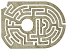
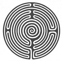
Near Wing, in Rutland, a few miles to the north-east of Uppingham, there is preserved a maze of very similar design (Fig. 60). It is maintained in good condition and is still the object of periodical visits by the village folk on certain holidays. Just to the south of it is a flat-topped bowl-shaped tumulus, over 70 ft. in diameter and
Click to enlarge
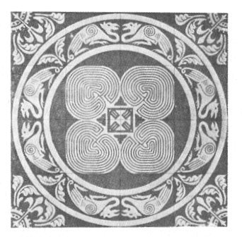
Fig. 56.
Labyrinths on Tiles, Toussaints Abbey, Chalons-sur-Marne. (Amé)
(see page 65)
Click to enlarge
Fig. 60. Turf-Labyrinth at Wing, Rutland.
(Photo, W. J. Stocks. By permission of Rev. E. A. Irons)
[paragraph continues] 4 ft. high. It may be that the frequent association of turf mazes with ancient earthworks of various kinds is something more than accidental, but we do not seem to have sufficient evidence to establish a necessary connection between the two things.
Lyddington, another Rutland village, has also been mentioned as possessing a turf maze. A writer in the Rutland Magazine in 1907, for instance, says, in speaking of Priestly Hill, which overlooks the village on the east, "at one time there was a turf maze on its slope, where, as our old people tell us, their grandparents, when children, used to play." The writer in question, however, does not make it clear whether he is really quoting an oral tradition of the locality or is basing his statement on the brief mention of Lyddington as a reputed maze-site which appears in Trollope's 1858 memoir. It is at any rate very difficult to trace any reliable evidence of such a maze, and it seems not unlikely that Trollope's reference, which is quite devoid of detail, may have had its origin in a misinterpretation of the elaborate series of ancient trenches situated in a field to the north-east of the church. These trenches have been identified as the "fish-stews" belonging to the old manor-house of the Bishops of Lincoln.
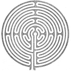
The similarity between the designs of the turf mazes mentioned above and those of some of the French pavement labyrinths, that in Chartres Cathedral for example, cannot fail to be noticed.
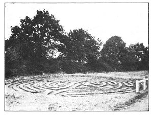
At Boughton Green, in Northamptonshire, about half a mile from the village of Boughton and near the ruined church of St. John the Baptist, was, until recently, a turf maze of like design but having the innermost convolutions of purely spiral form (Fig. 61). It was 37 ft. in diameter and was called the "Shepherd Ring" or "Shepherd's Race." The "treading" of it was formerly a great feature of the three days' fair in June, an event dating from a charter by Edward III. in 1353.
In a "Guide-book to Northampton" by G. N. Wetton, published in 1849, the maze is spoken of as being in a neglected condition. In a later book, however, a novel named "The Washingtons," written by the Rev. J. N. Simpkinson in 1860, occurs the following passage: "He had just been treading the 'Shepherd's Labyrinth,' a complicated spiral maze traced there upon the turf; and
Click to enlarge
FIG. 61.—''Shepherd's Race,'' Boughton Green, Northants. (After Trollope.)
was boasting of his skill, how dexterously and truly he could pursue its windings without a single false step, and how with a little more practice he would wager to go through it blindfold."
Another novel, "The Last of the Climbing Boys," by George Elson, contains a reference to it, in which it is spoken of as being "An attraction which was the origin of the fair"—a statement which it would be interesting to verify if possible.
Unfortunately, this famous relic was destroyed by
some of our soldiers in training during the Great War; trenches were driven right across it, and practically all traces of it are now obliterated.
There was formerly a specimen of somewhat similar design on Ripon Common, Yorkshire, but this was ploughed up in 1827. One of identical pattern at Asenby, in the same county, was preserved until recent times. According to Mr. A. H. Allcroft ("Earthwork of England," 1908), it was sunk in a hollow at the top of a hillock called "The Fairies' Hill," and is in a ruinous condition, being quite unknown to most of the villagers, although persons still living (in 1908) relate that they have often trodden it on a summer's evening and knelt at the centre "to hear the fairies singing."
The counties of Yorkshire and Lincolnshire seem to have been particularly rich in records of these devices, for in addition to those already mentioned we read of one on the wold overlooking Louth, one at Horncastle, a dozen miles to the south-west of Louth, one in Holderness, between Marfleet and Paul, about four miles from Hull, and another at Egton, near Whitby, where the late Canon Greenwell in 1872 saw traces of it near the main road to the north of the village. "July Park," or "St. Julian's," near Goathland, is also said to have possessed a specimen, a fact which probably accounts for the name of the place. The Horncastle maze is referred to by Dr. Stukeley, a noted eighteenth-century antiquary, as a "Julian's Bower" which is "much talked of." He also mentions the Alkborough specimen and others, coming to the conclusion that they were ancient British relics, having been constructed as places of exercise, or cursus, for the soldiery of those times. He observes, somewhat contemptuously, that "lovers of antiquity, especially of the inferior classes, always speak of ’em with great pleasure, as if there was something extraordinary in the thing, though they cannot tell what."
The Louth "Gelyan Bower" is mentioned in a record
of 1544, "To nych mason for making at gelyan bower a new crose, iijs." In an old hostelry in Mercer Row, Louth, stood for some centuries a boulder of dolerite called the "Blue Stone," which is stated to have formerly occupied the centre of the maze. Trees planted at the maze served as a landmark to ships out at sea.
The Horncastle example occupied a site to the south-west of the town still known as the Julian Bower Close. It has long been effaced by the agriculturist, and numerous coins, fibulae, and other Roman remains which have been turned up on the spot have lent colour to the theory, still maintained in the current county directory, that the maze was a Roman work. The question whether this, or any other turf maze in this country, is a relic of Roman times we will discuss presently.
The maze near Hull was dodecagonal in outline, 40 ft. across, and formed of grass paths 14 in. wide. Its plan was much like that of the Alkborough maze, but the paths were straight instead of curved. It was called "The Walls of Troy." A coloured illustration of it was given in Ackermann's "Repository of Arts" in 18 15.
Although, as we have seen, Lincolnshire furnishes us with records of more of these labyrinths than any other county, there is no conclusive evidence that they were in fact more numerous there than elsewhere. The reason for our comparative wealth of information concerning their existence in that part of the country may be due to the fact that Dr. Edward Trollope, who first made a serious study of these antiquities, and whose paper in the Archaeological Journal for 1858 has been a fount of inspiration to subsequent writers on the subject, was Archdeacon of Stow, afterwards Bishop of Nottingham.
Turf labyrinths were formerly of general occurrence throughout the country, for, in addition to those we have already described, we find remains of them in counties so widely separated as Kent and Cumberland. They are also recorded as having existed in Wales and Scotland.