Click to enlarge
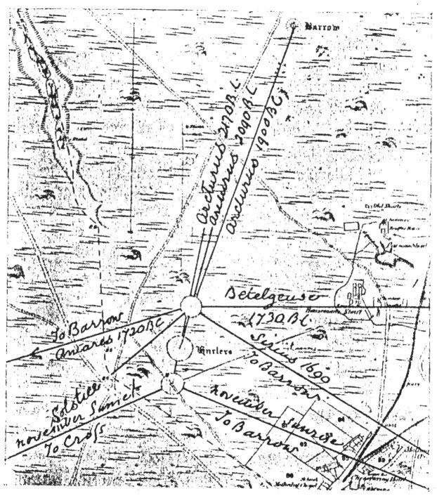
FIG. 41.—The Sight-lines at the Hurlers.
Stonehenge and Other British Stone Monuments Astronomically Considered, by Norman Lockyer, [1906], at sacred-texts.com
THE sight-lines to which I have drawn attention in relation to the stones of Stenness had to do with the places of sunrise and sunset in the May and Solstitial years. I now pass to another group of circles in which we deal chiefly with the places of star-rise and star-set, some of the stars being used as warners for sunrise at the critical times of the two years in question.
Following the clue given me in the case of the Egyptian temples, such as Luxor, by successive small changes of the axis necessitated by the change in a star's place due to precession, I began this stellar branch of the inquiry by looking out for this peculiarity in an examination of many maps and plans of circles.
I very soon came across two examples in which the sight-line had been changed in the Egyptian manner. The first is the three circles of the Hurlers, some 5 miles to the north of Liskeard, a plan of which is given in "Prehistoric Stone Monuments of the British Isles: Cornwall," by W. C. Lukis, Rector of Wath, Yorkshire, published by the Society of Antiquaries, who were so good as to furnish me with a copy, and also
some unfolded plans on which sight-lines could be accurately drawn and their azimuths determined. I am anxious to express my obligations to the council and officers of the society for the help thus afforded inc.
The three circles are thus referred to by Lukis in the valuable monograph which I have already mentioned.
“On the moor, about a mile to the south of the singular pile of granite slabs, which rest upon. and overlap each other, and is vulgarly called the Cheesewring, there are three large circles of granite stones placed in a nearly straight line in a north-north-east, and south-south-west direction, of which the middle one is the largest, being 135 feet in diameter, the north 110 feet, and the south 105 feet.
“The north Circle is 98 feet, and the south 82 feet from the central one. If a line be drawn uniting the centres of the extreme Circles, the centre of the middle ring is found to be 12 feet 6 inches to the west of it.
“These Circles have been greatly injured. The largest consists of 9 erect and 5 prostrate stones; the north Circle has 6 erect and 6 prostrate, and a fragment of a seventh; and the south has 3 erect and 8 prostrate. In Dr. Borlase's time they were in a slightly better condition. A pen-and-ink sketch made by him, which is extant in one of Dr. Stukeley's volumes of original drawings, represents the middle Circle as consisting of 7 erect and 10 prostrate stones; the north of 10 erect and 6 prostrate; and the south of 3 erect and 9 prostrate. The stone to the east of that marked C in the plan of the middle Circle is the highest, and is
[paragraph continues] 5 feet 8 inches out of the ground, and appears to have been wantonly mutilated recently. Two of the prostrate stones of the north Circle are 6 feet 6 inches in length.
“About 17 feet south from the centre of the middle Circle there is a prostrate stone 4 feet long and 15 inches wide at one end. It may possibly have been of larger dimensions formerly, and been erected on the spot where it now lies, but as Dr. Borlase has omitted it in his sketch it is probably a displaced stone of the ring.
“If we allow, as before, an average interval of 12 feet between the stones, there will have been about 28 pillars in the north, 26 in the south, and 33 in the middle Circle.
"At a distance of 409 feet westwards from K in the middle Circle there are 2 stones, 7 feet apart, both inclined northwards. One is 4 feet 11 inches in height out of the ground, and overhangs its base 2 feet 7 inches; the other is 5 feet 4 inches high, and over-hangs 18 inches."
I now pass from a general description of the circles to the azimuths of the sight-lines already referred to, so far as they can be determined from the published Ordnance maps.
To investigate them as completely as possible without local observations in the first instance, I begged Colonel. Johnston, R.E., C.B., the Director-General of the Ordnance Survey, to send me the 25-inch maps of the site giving the exact azimuth of the side lines. This he obligingly did, and I have to express my great indebtedness to him.
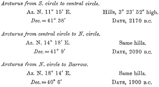
In Fig. 41 I show the sight-lines from the south and north Circles as determined by the stones and barrows marked on the map. The sight-lines on Arcturus are from
Click to enlarge
FIG. 41.—The Sight-lines at the Hurlers.
the centres of the three circles in succession. 1 shall point out later the significance of the fact that the November alignments are from the south, the solstitial ones from the north Circle.
Of the various sight-lines found, those to which I wish to direct attention in the first instance, and which led me to the others, are approximately, reading the azimuths to the nearest degree,
|
Lat. 50° 31´ N. |
Az. |
|
S. circle to central circle |
N. 12° E. |
|
Central to N. circle |
N. 15° E. |
|
N. circle to tumulus |
N. 19° E. |
In a preliminary inquiry in anticipation of the necessary local observations with a theodolite, I assumed hills half a degree high, for the reason given on p. 112. We have the following declinations approximately:—
|
Dec. |
N. 38½° |
|
„ |
38° |
|
„ |
37° |
Here, then, we have declinations to work on, but declinations of what star? To endeavour, to answer this question I studied the declinations of the three brightest stars in the northern heavens, having approximately the declinations in question some time or other during the period 0 to 2500 B.C.
Vega is ruled out as its declination was too high. The remaining stars Capella and Arcturus may have been observed so far as the declinations go. For time limits we have:—
|
Dec. N. |
Capella. |
Arcturus. |
|
38½° |
500 B.C. |
1600 B.C. |
|
36° |
1050 „ |
1150 „ |
Now there is no question as to which of these two stars we have to deal with, for the northern circle is
evidently less ancient than the others, for some of the stones are squared and the others are less irregular than those in the S. circle.
This being so, the approximate dates of the use of the three circles at the Hurlers can be derived. They are, with the above assumption:—
|
|
|
|
|
|
B. C. |
|
Southern |
circle aligning |
Arcturus |
over centre of |
central circle |
1600 |
|
Central |
„ |
„ |
„ |
N. circle |
1500 |
|
Northern |
„ |
„ |
„ |
tumulus |
1300 |
The next step was to obtain, by means of a large circular protractor, more accurate readings of the Ordnance Map. This I could do, but the all important question of the angular height of the horizon remained. As it was impossible for me to leave London when the significance of the alignments was made out, I appealed to the authorities of the Royal Cornwall Polytechnic Society for aid in obtaining the necessary angles, and as a result, Captain J. S. Henderson, of Falmouth, an accomplished surveyor, volunteered his aid and shortly sent me the angular heights along some of the alignments, the means of eight readings obtained with a 6-inch theodolite, both verniers and reversed telescopes being employed. Other students of science besides myself will, I am sure, feel their indebtedness for such opportune help.
The combination of the large protractor and theodolite work gives the following final values. The difference between them and the provisional ones given above speaks volumes as to the necessity of a local study of the height of the horizon, a point I believe invariably neglected by archæologists.
FINAL VALUES.
Now before this evidence of star worship, so important if it can be depended on, could be accepted, it was necessary to make a special inquiry as to, the existence of similar star observations in other places. Many have been found of which more in the sequel.
The next point which arose was that Arcturus used as a clock-star (p. 108) would serve as a warner for August. This necessitated another inquiry into the chief festivals in Cornwall: among these the August (Harvest) festival is one.
Another point to consider was whether there was any evidence of a local August festival. It happens that the Hurlers are in the parish of St. Cleer, and some of the other Arcturus sight-lines are in that of St. Just. Now, a local festival in old days was often associated with the local Saint. As most of the Cornish Saints are common to Cornwall and Brittany, I looked up the Calendar of the Annuaire of the Institut de France, and found that the days dedicated
to SS. Justin and Claire are the 9th and 12th of August. It seems, then, that at the Hurlers it was really a question of a clock-star also used as a warning star for the August festival. I think we have at last, then, run to earth the origin of some of the northerly alignments referred to on pages 36 and 43.
It will have been noted that the last sight-line on Arcturus was marked by a barrow. Captain Henderson inspected it and found it much ruined by explorers, remains of a chamber inside being visible.
In a subsequent visit, in which Captain Henderson was accompanied by Mr. Horton Bolitho, my wife and myself, we not only visited this barrow, but found that the whole hill had been honeycombed to such an extent by mining operations that it was very difficult to discriminate between "investigated" barrows and other heaps and holes, unless the barrow showed the remains of a chamber.
Our examination was not limited to barrows. Captain Henderson had spent a long bleak day in examining and measuring the stones marked on the Ordnance Map, to which I had called his special attention. We went over part of the ground with him, and came to the conclusion that the whole question of the Cornish treatment of "ancient stones" would have to be gone into—an inquiry which Mr. Bolitho is now carrying on.
It must be remembered that any stone or barrow used in the sight-lines we are now considering must have been put up nearly 4,000 years ago, so long ago, in fact, that many of the chief barrows have been reduced to the skeletons of their former selves, the
enclosed stone chamber, built of mighty stones, alone remaining:
Cromlechs and standing stones then formed important points in the landscape long before ecclesiastical divisions were thought of, or any attempt was made to indicate the boundaries of private property.
We should expect then to find these ancient monuments freely made use of to mark what we now term "parish boundaries." This is so. Four parishes have thus used one of the larger cromlechs, and it is more than probable that something beside the denunciation of the cultus lapidum, which we have seen at work in Brittany (p. 39), has been responsible for the many stone crosses in Cornwall. Of some of them near circles I have gathered the astronomical use, while now they "mark the bounds," as do some of the stone rows in Dartmoor.
I believe that in later times this practice of the Church was followed by those among whom the land was distributed, and this has gone on till at last there are many ancient stones trimmed on one side and bearing initials and so having a modern appearance. The astronomer, and even the archaeologist, may regret this practice, but as the habit in Cornwall appears to be for anybody to use the nearest uncrossed and uninitialled stone for a wall or a pigsty, Mr. Bolitho's inquiry may show that in some cases, at all events, it has been a blessing in disguise, for the stones are still there.
In the case of a long chambered barrow, the top of which nearly touches the horizon, as seen from a circle near it, there is less danger of being misled.
In my notes on the stones of Stenness (Chapter XIII) I pointed out that the chambered Cairns at Onston and Maeshowe suggested that such structures were later variants of the more ancient standing stones. Some barrows at the Hurlers lend further confirmation of this view. I will deal with them first. Of one the data are Az. from N. Circle S. 72° 49´ W., height of horizon 12´ (Capt. Henderson). The resulting declination is S. 11° 5´, the declination of Antares 1720 B.C. But why should Antares be thus singled out? The table on page 117 shows the reason. At the date involved the setting of Antares in the dawn was the warner of the sunrise on May morning, the greatest day in all the year.
Is there any precedent for this use of Antares?
I have already pointed out (p. 108) that Mr. Penrose found the warning stars for May morning at the dates of foundation of the Hecatompedon, and the older Erechtheum, to be the group of the Pleiades rising and Antares setting. As the foundations of the Hecatompedon were built only some few years after the stones of the central circle of the Hurlers were used, we ought to find traces of the observations of the same May-morning stars.
We have, then, now a third term in the astronomical use of stars to herald the sunrise on May morning.
|
Temple of Min |
Thebes |
3200 B.C. |
Spica. |
|
Temple at the Hurlers |
Liskeard |
1720 „ |
Antares. |
|
Older Erechtheum |
Athens |
1070 „ |
„ |
The next barrow to be referred to—it is shown to be a long one on the Ordnance Map—is situated
near the top of Caradon Hill, and is visible, on the skyline from the circles. Data: Az. from N. Circle S. 65° E., height of horizon 1° 38´ (Henderson). This corresponds almost exactly with the azimuth of the rise of the sun's upper limb with declination S. 16° 20´ on the two critical dates in November and February of the May-year (Halloween and Candlemas, see p. 23), so I am. inclined to consider it more than a mere coincidence that the azimuths coincide so closely. It, however, may be urged that there are other barrows on Caradon Hill, but judging from the Ordnance Map they seem to be of the round variety used for burials, perhaps a thousand years after the circles were in use, and in my opinion by a different race of men; but this matter must not detain us now, I hope to return to it later.
Still one more barrow and a stone, uncrossed and uninitialled, in the same sight-line, data: Az. from N. circle S. 59° 35´ E. Height of horizon 1° 38´ 23″ (Henderson), resulting declination S. 19° 50´. This was the declination of Sirius 1690 B.C. Why Sirius? The table on p. 117 gives us the answer. Sirius replaced Arcturus as a warning star for the August festival, and we have seen that the last use of Arcturus was connected with the sight-line to the barrow about 1900 B.C.
I pass now from barrows to stones. There is one about which there can be no question. It is a famous Cross, a "Longstone" at which all travellers stop on their way from St. Cleer to the Hurlers. It occupies nearly the same position on the S.W. horizon as does the long tumulus on Caradon Hill in the S.E. quadrant. From the South Circle, and this is important, its
[paragraph continues] Azimuth, S. 64° W., is nearly the same; it marked, and still marks, the sunset point on the critical days of the May year in November and February.
There is another stone marked on the Ordnance Map Az: N. 88° E. from the N. circle. It Chas been removed, so I may fairly assume that it was really an ancient stone. Captain Henderson's value for the height of the horizon is 11´ 31″. The table on p. 117 will show that in this direction we have to deal with Betelgeuse as a warner for the summer solstice. The resulting date is 1730 B.C.
It would appear that possibly this is not the only stone dealing with (later) solstitial alignments. Lukis gives two stones on the west side of the circles which on the Ordnance Map are classed as boundary stones: they lie on a boundary beyond all question, but also beyond all question they are as ancient as the stones(of the circles themselves. From the N. circle they are almost but not quite in a line, and the azimuth of the south stone is S. 49° W. This is a solstitial azimuth. I think, therefore, that we may accept this as another evidence of the worship of the setting sun at the winter solstice, from the N. circle, and in this we, have still further evidence that to the worship of the May year in the south circle was added later one dealing with the solstitial year which was chiefly carried on in the N. circle.